Insights


A few weeks ago, I received a beautiful rose from my daughter for my birthday. I did not have a vase for it so I used an old glass milk bottle and it worked just as beautifully as a vase. Have you ever had a similar situation where you found a new use for an old item?
Sustainability is about preserving the resources that we have and giving them new life by assigning new functions.
Many of our dams and hydropower projects in the U.S. have been in operation for decades. In order to meet regulatory requirements, many studies have been performed on these projects, which often resulted in various hydrologic and hydraulic models, such as HEC-HMS, HEC-RAS, HEC-ResSim, etc.
Each of these models was originally developed with a specific purpose, but once the project was complete, the models were put on the shelf and seldom used again.
Do you ever wonder if there are ways to make these models more effective? The answer is yes! Your existing models have the power to be turned into real-time decision-support tools. Let’s dive into a few examples regarding flood mapping and reservoir operations.
Real-time Flood Mapping
In the U.S., dam failure analyses and inundation mapping have been completed for almost all “high” and “significant” hazard-potential dams. These exercises typically focus on sunny-day and Inflow Design Flood (IDF) conditions using pre-defined inflow hydrographs and hypothetical dam breach scenarios. They generally don’t account for more common scenarios, like:
- Experiencing a 50-year storm instead of an IDF
- Failure of the embankment instead of the concrete spillway occurring during a flood event
- Potential inundation from a downstream levee failure to plan for emergency evacuation
The reality is that every storm event is different and can result in very different inundation conditions and demand for emergency flood management.
By connecting your existing HEC-RAS models to sources of inflow forecast, we can turn your model into a real-time flood mapping tool. With real-time inflow forecast, you can estimate the actual projected inundation in the downstream area and make meaningful emergency management decisions.
Various sources of inflow forecast are available. The National Weather Service River Forecasting Centers provide river forecasting at approximately 3,700 locations on major waterways in the U.S. Another product by the National Weather Service, the National Water Model, provides seamless river forecasting at over 2.7 million river reaches throughout the country. In some cases, sources of rainfall forecast can be used in conjunction with your existing HEC-HMS and HEC-RAS models, providing more data to analyze for more accurate insights.
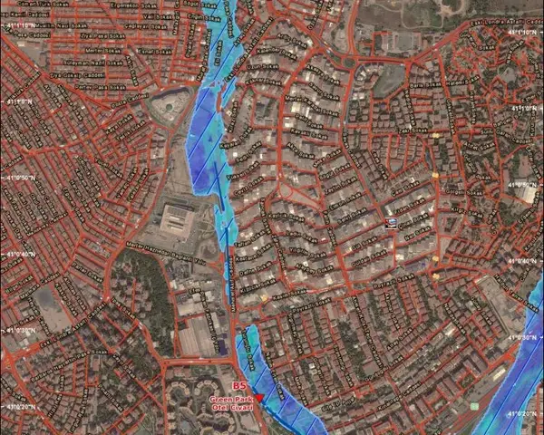
Figure 1. Real-time flood mapping for Istanbul, Turkey
Figure 1 demonstrates a real-time mapping system for Istanbul, Turkey. In this case, a forecasting framework, Delft-FEWS, was configured to link in real-time to rainfall forecasts with a hydrologic model, SAC-SMA, and the resulting channel flows with inundation maps produced using existing hydraulic models - HEC-RAS and MIKE 11 - originally used for infrastructure analyses.
Forecast Informed Reservoir Operations (FIRO)
Historically, reservoir operations have been performed based on pre-defined rule curves while real-time operations are performed based on operator experience. As we are challenged by more variations in hydrologic conditions due to climate change, and the need to achieve better balancing of multiple functions of hydroelectric facilities – water supply, flood control, energy generation, environmental needs, and recreation – hydro operators are required to manage their reservoirs with greater agility and flexibility.
Forecast Informed Reservoir Operations (FIRO) is a new approach that allows reservoir operations to be guided based on real-time river forecasting information rather than rule curves based on historical weather patterns.
If you have an existing reservoir model, such as HEC-ResSim or Riverware, chances are your model can be converted into a real-time reservoir operations decision-making tool by linking to a river forecast source. With predicted river flow, operators can test different reservoir operation schemes ahead of time and plan for storage or releases several days in advance. With this data-driven approach, combined with operator knowledge about the watershed, better decisions can be made to optimize the use of precious water resources.
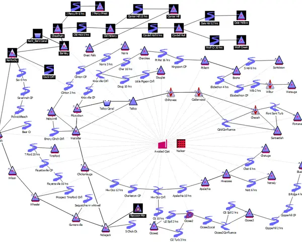
Figure 2. TVA’s Riverware Model of the Tennessee Valley System
Figure 2 demonstrates the Riverware model of the Tennessee Valley System - a real-time decision-support system that TVA uses to manage their river system. With this model, TVA averted $1.7 billion worth of damage in the region during the February 2019 historical rainfall event.
With more than 30 years of experience in river forecasting and reservoir operations, RTI’s Center for Water Resources has the knowledge and tools to help you take full advantage of your existing tools as real-time decision-making assets. In addition, we provide training to help our clients better understand and optimize utilization of their systems.
We understand that not all hydro owners are equipped with in-house technical capabilities to run comprehensive models. To help, we design simple and intuitive web-based interfaces that allow hydro operators to input key parameters and receive instant results. We can also host and perform the analysis as a subscription-based service and regularly provide the appropriate results.
Check out our work with the TVA and Panama Canal to see how the RTI Center for Water Resources partners with clients regarding real-time decision making.
Disclaimer: This piece was written by Yiying Xiong (Senior Water Resource Engineer) to share perspectives on a topic of interest. Expression of opinions within are those of the author or authors.


