Insights


Our lives are influenced daily by Earth observation data, which are integrated into countless products and services we all benefit from (e.g., weather forecasting, precision agriculture). But there is still huge untapped potential for these data. To unlock this potential, government agencies and companies must spend extra time and effort engaging with the people who do not fully realize its benefits.
What is an Earth observation?
Earth observation refers to any data and products derived from Earth-observing systems and surveys. It is conducted by governments and companies using many sources, including satellites with instruments that take pictures of the Earth, airplanes that measure how much snow is on a mountain, and sensors in rivers that estimate how much water is flowing that day. It is the source of valuable insights that enable people to adapt to and mitigate weather and climate change, strengthen environmental monitoring, and improve human health and safety.
Understanding the Earth observation value chain
Earth observations only provide value when people are able to access them in a timely manner, understand them, and modify their actions as a result of the data. For this reason, it is important to understand the Earth observation value chain (see Figure 1). Data collection is just the start of this value chain. For data to be useful, it needs to be analyzed by experts, integrated into understandable websites, apps, or publications, and then used to inform decision-making by an end user—like a farmer, an insurance company, or a person living in a city that is forecast to be impacted by a hurricane.
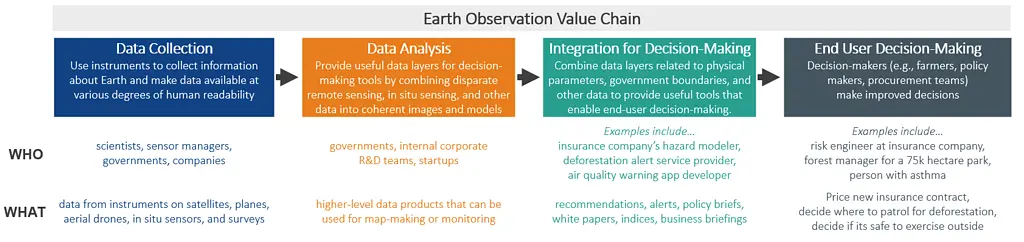
Figure 1. Earth observation value chain annotated with the types of organizations involved at each step of the value chain and what they create.
Unequal benefits from Earth observations
Collecting, processing, and using Earth observation data requires deep expertise and resources. As a result, it has not benefited all people equally. There are many reasons for this, including historical and current data gaps (i.e., when and where the data is collected), challenges in analyzing and integrating
Earth observation data for decision-makers (e.g., data accessibility, data heterogeneity and interoperability, cost of storage and processing), and helping end users access and trust the data before they make a decision. All of the steps along the Earth observation value chain are expensive, and companies and governments have to make tradeoffs when designing their Earth observation-driven services.
These tradeoffs lead to inequities on multiple scales. For example:
- A town did not have access to a private company’s tornado alert system but a railroad company did, resulting in dozens of town residents losing their lives in the tornado while the railroad company’s trains avoided it.
- Tribal nations face challenges when forecasting and planning for drought because there have not been sufficient or consistent hydrology, snow cover, and surface water-type observations on their lands.
We need to address the unique challenges communities face across the value chain by co-developing solutions that leverage their equally unique strengths.
How agencies and companies can collaborate to unlock the value of Earth observation data
Across the Earth observation value chain, user communities fit into two archetypes:
- Communities of practice: private-sector companies, research institutes, scientists, and professionals that understand and use Earth observation data today. These communities use the same terminology to talk about Earth observation, actively monitor and try out new innovations in this space, and have well-informed opinions about challenges and opportunities related to its collection, processing, and use.
- Communities of potential: people and organizations that have the potential to benefit from Earth observation data but have limited historical use of the data. These communities may or may not be aware of Earth observation data, and they are less familiar with terminology used by the communities of practice to describe their needs and priorities. Early adopters in these communities may exist, but barriers along the value chain prevent or slow them from broadening the benefits of data across their communities.
To unlock Earth observation data’s potential, both communities must engage with each other through open dialogue and collaboration. While this engagement takes time and resources, it is critical for paving the path towards greater and more equitable impacts across communities.
User-centered design must drive co-development of new products and services
In user-centered design, the user’s characteristics, environment, needs, and interests are considered at each stage of the design process, leading to new products and services that are optimized to match people’s thinking and help them accomplish their goals (Figure 2).
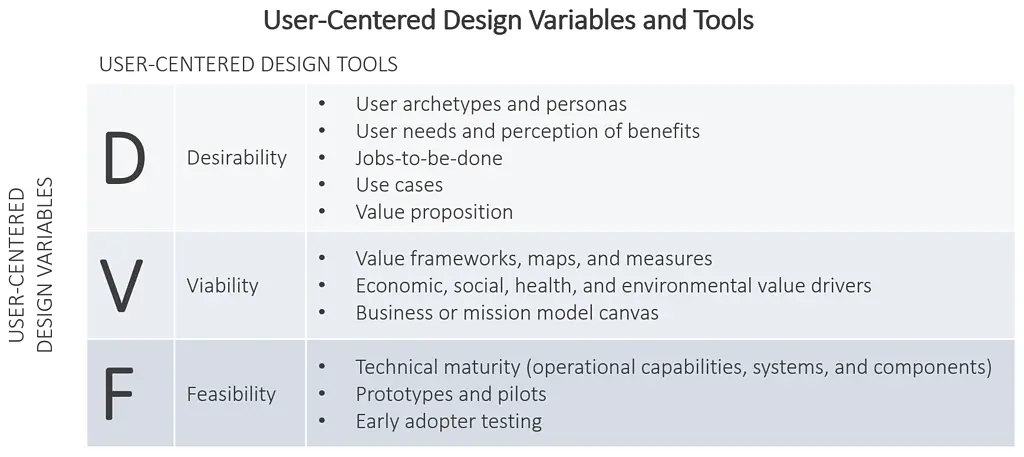
Figure 2. User-centered design tools that can be leveraged in a user-centered designed approach to developing new Earth observation products and services.
Governments and companies that are developing new products along the Earth observation value chain should engage with existing partners in their communities of practice and end users in the communities of potential to understand the user desirability of new data products or decision-making tools. It’s critical to recognize that the end users are deep experts in their contexts and the decisions they make. Product developers should listen for barriers they experience now and consider how those can be overcome.
By centering the user, product developers can also translate needs from across communities into priorities for data collection or down-stream product creation. In so doing, they will have to consider economic viability of different options (e.g., the cost of adding more satellites to the mission to increase how often data is collected) as well as feasibility.
This user-centered design approach is complicated, especially for governments synthesizing needs across diverse global communities. RTI has deep expertise and experience engaging through this lens to translate end-user needs into prioritized data collection and down-stream product priorities for our partners. We deployed this user-centered approach for NASA, philanthropic foundations, and other organizations.
Leveraging Partnerships for Earth Observation Data
Investing time and money into partnerships that leverage the complementary strengths of these communities can lead to a step-change in the value of Earth observation data in the next decade (Figure 3).
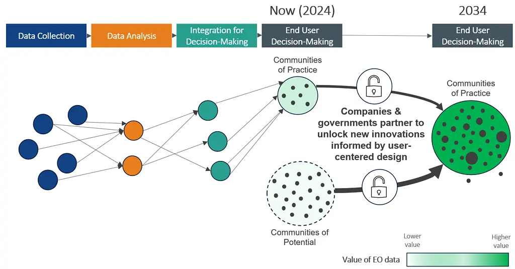
Figure 3. Companies and governments can partner to unlock new innovations – informed by user-centered design – that increase the value of Earth observation data to existing Communities of Practice, as well as developing today’s Communities of Potential into future Communities of Practice.
Public- and private-sector data providers and companies need to understand user needs and translate new and existing data products into decision-making tools that empower new users. Government actors and philanthropies need to be willing to spend more resources to reach untapped communities of potential. End users should be engaged in a collaborative, respectful, two-way interaction—not an “extractive” interaction that checks a box.
Recognizing the critical importance of partnering with and leveraging the strengths of those across the value chain will, in turn, drive and grow thriving communities of practice and empower entrepreneurs and end-users scattered across communities of potential today.
This blog is developed in response to the U.S. Group on Earth Observations (USGEO)’s National Plan for Civil Earth Observations. Read our full response here.
Disclaimer: This piece was written by Tyler Ovington (Innovation Advisor) and Kirsten Rieth (Director, Research and Insights) to share perspectives on a topic of interest. Expression of opinions within are those of the author or authors.