Newsroom
RTI researchers are tracking the spread of coronavirus using Twitter Geolocation
RESEARCH TRIANGLE PARK, N.C. — 2019-novel coronavirus, proclaimed yesterday by the World Health Organization as a public health emergency of international concern, has impacted thousands of people globally, and as of Friday, has led to over 200 deaths. Researchers at RTI International, a nonprofit research institute, in collaboration with researchers from Harvard University, University of Oxford and University of Toronto, have been working to understand the spread of the 2019-novel coronavirus by using geolocation data from the social media platform Twitter.
Donal Bisanzio, DVM PhD, Senior Epidemiologist at RTI, and Richard Reithinger, PhD, Vice President of Global Health at RTI have been studying the virus since cases began to be reported in early January.
According to the geolocation data, public health officials should anticipate new cases in new countries to soon be reported based on a correlation between geolocated data from a group of Twitter users from Wuhan and the original location of previously reported cases of the virus.
“We chose to review geolocations of Twitter users because data of travelers during the inception of the virus had already been studied using flight information, census surveys and mobile phone traffic — these methods do not necessarily allow identification of intermediate or final travel destinations,” said Reithinger. “Geolocated data of Twitter users had not yet been studied and by identifying where tweets from this time period originated, we can get a better idea of exactly where these users physically were.”
Bisanzio and Reithinger created a database of tweets during the time period of when exposure to coronavirus first occurred up until travel into and out of Wuhan became restricted by Chinese authorities as part of their response to the outbreak.
They filtered the database to include users who posted at least two tweets on consecutive days within the city of Wuhan to ensure that each user was physically in Wuhan. After filtering the pool of users, they reviewed the group’s activity on Twitter for a 30-day period to determine whether they had traveled outside of Wuhan based on the geolocated data from each of their tweets.
The researchers expect new cases to be reported in the U.K. (two of which were confirmed this morning), Saudi Arabia and Indonesia — all countries in which the group of Twitter users traveled to based on geolocated data within 30 days after tweeting from Wuhan more than once.

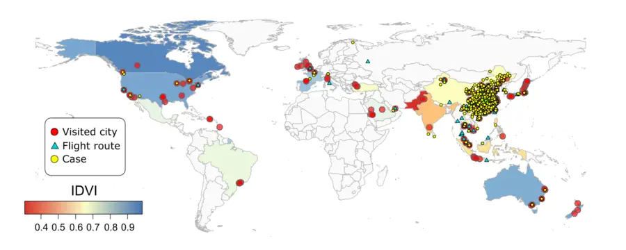
Of the nearly 1,344 Twitter users Bisanzio and Reithinger studied, 133 users traveled to 157 locations in China and 60 users traveled to 119 locations in 28 countries during the time period studied, including the U.S., Thailand, Saudi Arabia and Australia. This means that some of the users studied traveled to many locations in a very short period — increasing the probability of the spread of the virus.
“Based on our research, we anticipate new cases of coronavirus to soon be reported,” said Reithinger. “Our main message to health officials is that if your city is on the map or close to where the study’s Twitter users visited, draw up plans to sensitize the population and health providers to the possible emergence of 2019-novel coronavirus, particularly in patients with a history of travel to Wuhan.”
For more information and to read the full study, click here.
An update of this study was published in Geospatial Health in June. To read more, click here.
Learn more about our COVID-19 Research.
RTI International is an independent scientific research institute dedicated to improving the human condition. Our vision is to address the world's most critical problems with technical and science-based solutions in pursuit of a better future. Clients rely on us to answer questions that demand an objective and multidisciplinary approach—one that integrates expertise across social, statistical, data, and laboratory sciences, engineering, and other technical disciplines to solve the world’s most challenging problems.
For more information, visit www.rti.org.