Key Policy Implications
Work seekers face a range of geographic (spatial) barriers to employment—commute time and costs, infrastructure and transportation service gaps, residential location bias, and suboptimal professional networks, among others—yet labor market information systems, especially in the developing world, do not collect and analyze geospatial data.
Case studies from South Africa and Kenya presented in this brief show the importance of geospatial labor market data and how they can be used to improve programs and policy.
Educators can use geospatial data to better understand their incoming students and to track and learn from the employment journey of their alumni. Employers may benefit from knowing the commute time and costs of their employees, especially new hires. Policy makers need to understand spatial barriers to employment when making infrastructure, transportation, housing, education, and other social service investments.
Geospatial data can be difficult to collect and present in a useful way, requiring adequate technology and capacity.
Policy makers, researchers, and education providers benefit from knowing how long it takes work seekers to find employment once they finish education or training, how and where they search for employment, the quality of employment obtained, and how steady it is over time. Such school-to-work transition data are an important component of labor market information systems (LMIS). In less developed countries, these data are poorly collected, or not collected at all, a situation the International Labour Organization (ILO) and donors agencies have attempted to change (Elder & Cumming, 2016; Sparreboom, 2016). However, LMIS reforms typically miss a critical part of the picture: the geospatial aspects of these transitions (Hogrebe & Tate, 2012).
Few LMIS fully consider or integrate geospatial school-to-work transition information, ignoring data critical to understanding and supporting successful and sustainable employment: employer locations and employees’ relative distance from work; transportation infrastructure; commute time, distance, and cost; location of employment services; and other geographic barriers to employment.1
The Geography of Workforce Development
There are a range of theories, and some empirical data, on how geospatial variables impact employment outcomes (Preston & McLafferty, 1999). Empirical work in this area predominately stems from urban economic studies in the United States and considers dimensions of “spatial mismatch” that prevent the efficient connection of skill supply and demand. Examples of spatial mismatch include the physical distance between low-income housing and centers of productive employment; residential discrimination by employers; infrastructure and urban services–related transportation costs and commute times; information-related job search frictions; and the lack of social networks that can aid in finding and progressing in employment (J-PAL, 2013).
At an individual level, work seekers facing geospatial barriers to employment may not integrate into the labor force or may drop out of it over time. At a macro level, areas that experience high levels of spatial mismatch may suffer suboptimal economic growth (Li et al., 2013). Remedies include tailoring individual services and benefits (transportation subsidies, job search assistance, housing relocation and/or migration inducements) and making changes to urban planning policies (infrastructure and transportation development, housing development, employer relocation and investment packages) (J-PAL, 2013). The success of these interventions depends, in part, on quality geospatial school-to-work transition data.
Geospatial School-to-Work Transition Data
Geospatial technologies (i.e., satellite imagery, geographic information system software) have been applied to a range of international development sectors for decades. Common fields include disease surveillance, disaster planning and response, health systems strengthening, water and sanitation management, and natural resources management. Geospatial techniques have been applied in various aspects of education development, including mapping school locations and analyzing disparities in access to schools (Chavez, 2016; Eray, 2012). But the use of geospatial technologies in LMIS, and specifically school-to-work transition studies, has been less common.
The latitude and longitude of specific locations and/or place markers (e.g., a street address) constitute geospatial data. Using these data points and knowledge of infrastructure and services in various locations, one can measure distances and map the environment surrounding school-to-work transitions to inform LMIS. Five types of data are needed:
Students’ or graduates’ home of origin or their current residence, if different
Employer location, if the student or graduate is employed
Home-to-school or home-to-work commute options, durations, and costs
Location of education and employment services providers
Availability of labor market information, often requiring information communication technology assets such as access to cell phone and/or internet connection.
We provide two case examples of recently collected geospatial school-to-work transition data we collected in South Africa and Kenya to demonstrate the importance of these data and what they reveal.
South Africa
Harambee Youth Employment Accelerator is a not-for-profit social enterprise in South Africa that connects employers who are looking for entry-level talent to high-potential youth who are looking for work but lack the qualifications, finances, and networks needed to find jobs. Harambee runs short-term, demand-driven training programs, ranging from several days to several months, and places its graduates directly in employment. Harambee tracks each of its graduates for 2.5 years through periodic surveys, collecting the location, job-search behavior, employment outcomes, and commute-related data for employed training program alumni.
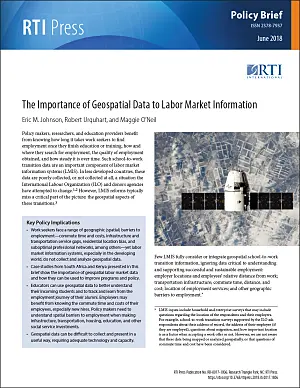
A 2017 survey by Harambee of its alumni in the Gauteng province received 9,159 responses; 25% of the respondents were employed. Analyzing commute-related data for those employed, Harambee found that its employed graduates spend an average of $27 per month on commuting to work and back, which is 13% of their average monthly household income of $211 per month. Harambee’s research indicates that labor market retention goes down significantly as its graduates spend more than 15%–20% of their disposable income on their work commute, as shown in Figure 1.
Harambee maps its alumni survey data to look for patterns in commute costs and labor market dropout correlations. Awareness of how commute costs vary by location allows Harambee to create and deliver services to segments of its graduates and improve labor market retention rates.
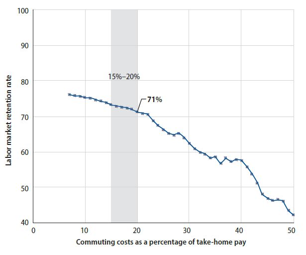
Harambee also asks its unemployed alumni how much they spend monthly in job search costs. In the 2017 Gauteng survey, Harambee found that work seekers spend an average of $26 per month looking for a job, 12% of their household budget. Wanting to understand how these job search costs vary by sub-region within Gauteng province (including the Johannesburg metro area), Harambee used geolocation markers from the surveys (i.e., reported home address or township name) to analyze average job search costs by location. Figure 2 shows these data and the significant variation by and within sub-regions.
Figure 2.
23112Median monthly job search costs of unemployed Harambee training program alumni in Gauteng, South Africa
These data show that certain areas of Gauteng and the City of Johannesburg metro area experience very high job search costs—from $27 to $39 per month (orange and red circles), a significant portion of average monthly household income.
As a result of collecting and analyzing these geospatial work commute and job search cost data, Harambee has done the following:
Made changes to its programs and services, including recruiting young people for opportunities in catchment areas within one taxi ride away from that opportunity.
Educated work seekers on how to maximize their job search and commute resources.
Advocated that its employer partners advance new employees their first month’s wage to offset initial, often insurmountable commute costs.
Lobbied government to increase transportation subsidies to bring down commute costs, particularly for minibus taxis, which are the transportation of choice for 71% of South African commuters but the recipient of less than 1% of public transportation subsidies.
Kenya
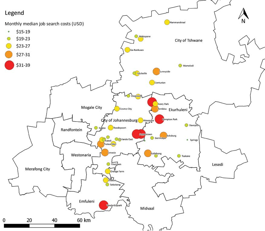
In 2016, we conducted research in Kenya to understand how (or if) Kenyan vocational training centers (VTCs) track their alumni. We found that 20 of the 23 VTCs surveyed did not collect alumni data but had keen interest in doing so. In particular, these schools are interested in knowing where their alumni are employed, what their job search process entails, and how effective their training has been in finding work. To demonstrate the potential impact of such data, we drew a random sample of 800 alumni from these 20 colleges and, using phone surveys, collected data from 421 alumni. Of these 421 respondents, one-quarter were employed and provided data on both their residential location and their employer’s location. From VTC records, we also had the graduates’ original home of record and the VTC’s location. Using ArcGIS Online mapping technology, we mapped these data to show VTC intake and outflow zones. Figure 3 shows where students of the program came from (the VTC’s intake patterns) and their employment locations after graduation (the outflow patterns) for one of the VTCs in the study, the Young Men’s Christian Association (YMCA) National Training Institute in Nairobi.
The top map shows the intake dispersion for the YMCA VTC, located in Nairobi, with students coming from an average of 162 km away and very few coming to the VTC from the same county. To serve these students well, the VTC must understand the cultural and educational backgrounds of a diverse student body far from home and provide appropriate services (housing, travel stipends, relocation support). The bottom map shows the employment locations of employed graduates, with roughly half employed in a cluster near the VTC (inset box) and another half traveling far from the school to find work—with a maximum distance of 416 km and an average distance of 110 km. These maps are consistent with internal migration patterns within Kenya, with a significant number of youth migrating from rural areas to Nairobi for school and work and some returning home, a pattern that can be seasonal in Kenya’s informal economy.
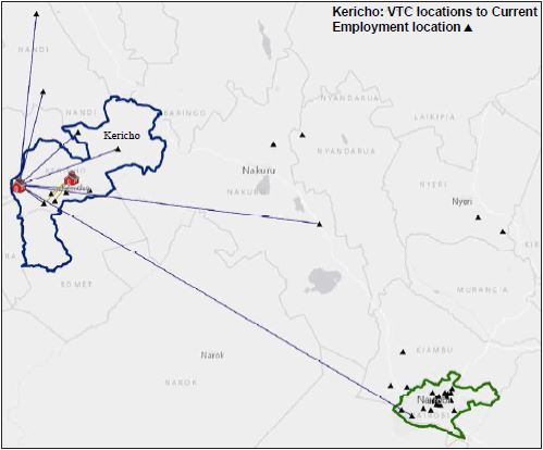
Figure 4 shows the outflow zones for two different VTCs in rural Kericho County. This map indicates that graduates of one of the two VTCs (blue lines) are mostly employed in Nairobi, 300 km away. The other VTC’s graduates (yellow lines) are all employed near the school within Kericho County. Although we have yet to explore the causes of these patterns, and such analysis is beyond the scope of this policy brief, some migration is likely specifically job related (i.e., construction graduates migrating to cities with more construction jobs).
Based on these data and maps, RTI is working with VTCs in Kenya to better understand the geographic aspects of their student intake and graduate outflow. The goal is to help VTCs tailor student services based on knowledge of where the students are coming from and going to and to align programs and curricula based on awareness of where alumni find work. This employment demand represents the targets to which these programs might align their offerings.
Considerations
Collecting, mapping, and analyzing school-to-work transition data is complicated and requires careful data collection and advanced software for analysis. In the Kenya case, we ran into positional accuracy issues, as student/alumni survey respondents provided county, sub-county, and ward names (themselves sometimes hard to decipher or locate), but not exact addresses or longitude and latitude coordinates. Using the center points of these sub-national areas meant that actual distances may be off by several kilometers or more. Even with more precise coordinates, education and training providers, researchers, or policy makers seeking to map these data need access to and skills in GIS mapping software, a capability many lack, especially in the developing world. Finally, alumni tracking itself is a broader field with its own limitations, including the cost and benefit of different survey approaches, often transient alumni populations, and response rate and data bias issues (Lau et al., 2018).
When data are successfully collected and maps are constructed, they should be analyzed from a “tri-dimensional point of view” (Chavez, 2016) that incorporates topographic contour lines, infrastructure realities, and public services dynamics, which we were unable to present here due to data limitations. Maps are visually interesting but are most useful when well-constructed, complete in their picture, and easy to interpret.
Policy Implications
Labor market information is critical to the conduct of effective workforce development. According to the ILO, school-to-work data can inform a range of economic, social, and education policies. Using labor market information, policy makers and researchers can
Determine how disadvantage/marginalization in the labor market varies across work seekers to develop policy that mitigates risks known to negatively affect the transition to decent work.
Develop policy that alleviates the mismatch of supply and demand between youth who are seeking work and employers who need employees with certain skills.
Develop geospatially informed LMIS to generate reliable data on employment conditions, wages and earnings, engagement in the informal economy, access to financial products, commute times and costs, and other experiences of young people in finding and maintaining employment, which are all important to labor market policy interventions (Sykes et al., 2016).
In each policy area, we submit that there is a particular need to understand geospatial aspects of school-to-work transitions. Adding location data will improve LIMS data and allow for better informed decisions about labor patterns and economic opportunities for individuals. Beyond labor market policy, policies related to housing and infrastructure development, industry development, and transport subsidies are also informed by these data.