
Products
Overview
MGSFlood is a purpose-built continuous rainfall–runoff modeling platform designed for stormwater design and green infrastructure planning in western Washington and other locations where continuous simulation approaches are required. MGSFlood realistically captures rainfall and runoff behavior for all storms on record rather than at discrete intervals as is typical in other design approaches. This allows practitioners to design stormwater solutions that protect stream stability, water quality, and aquatic habitat during all precipitation events.
Why continuous simulation? In many climates, especially rainfall-dominated regions, single-event or design-storm methods do not fully capture more frequent hydrologic events that most influence stream erosion, habitat condition, and stormwater volumes. Continuous simulation models evaluate the complete precipitation record and the resulting multi-year runoff response, giving designers and regulators the information needed to evaluate:
- Flow frequency and duration (how often and how long flows are elevated)
- Seasonal patterns and low-flow effects
- Cumulative runoff volumes and their effects on streams and infrastructure.
Because of these advantages, continuous simulation is required by the Washington State Department of Ecology’s 2024 Stormwater Management Manual for Western Washington (SWMMWW) and the Washington State Department of Transportation (WSDOT) for many design contexts.
Core modeling approach
MGSFlood uses the Hydrological Simulation Program–FORTRAN (HSPF) runoff routines to simulate land-surface and subsurface hydrology over multi-year periods. The model continually tracks moisture on the ground, in soil layers, and in groundwater, producing long timeseries of runoff and streamflow suitable for design, permitting, and environmental analysis.
Regional data and extended precipitation timeseries
MGSFlood is delivered with extended, high-resolution precipitation and evaporation timeseries developed for the Puget Sound region and the City of Seattle. These datasets:
- Provide 5-minute time-step records
- Combine and scale long-term hourly precipitation records from widely separated stations to create extended records in excess of 100-years
These extended timeseries are suitable for conveyance design, long-duration flow analysis, and regulatory compliance with the SWMMWW. RTI can develop comparable extended timeseries for other regions on request.
Features that matter to practitioners
- Intuitive drag-and-drop graphical interface for fast model construction and modification
- Automated compliance checks, including Facility Flow Duration Compliance per the 2012 Ecology Manual and workflows aligned with SWMMWW requirements
- “One-click” sizing and optimization routines for ponds and infiltration trenches
- Built-in Green Stormwater Infrastructure (GSI) simulation modules: bioretention, green roofs, porous pavement, and other low impact development (LID) facilities
- Stormwater detention and water-quality treatment sizing tools (design volume and discharge rate calculations)
- Stream channel simulation with complex cross-sections and floodplain interactions
- Wetland hydroperiod analysis tools
- Hydrograph export for routing in external hydraulic software (e.g., SWMM EXTRAN)
- Seasonal flood frequency and duration statistics to inform construction scheduling and risk management
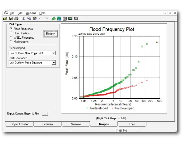
- Plotting, comparison, and reporting tools to demonstrate pre/post development outcomes and regulatory compliance
Why choose MGSFlood?
- Designed for stormwater professionals: MGSFlood focuses on the hydrologic processes and outputs most important to stormwater facility design, permitting, and ecological outcomes.
- Ready-to-use regional datasets: Users in western Washington gain immediate access to long-term, 5-minute precipitation and evaporation records that are otherwise complex and time-consuming to assemble.
- Extensible and customizable: Although optimized for western Washington, MGSFlood accepts user-supplied precipitation inputs and can be adapted to other regions. RTI’s hydrometeorological team stands ready to develop extended time series and regional parameter sets for projects outside western Washington.
- Faster, more defensible designs: Continuous simulation reduces uncertainty around flow duration and frequency and provides a stronger technical basis for LID, detention, and conveyance decisions.
- Support and services: RTI offers technical support and training.
Typical users and applications
- Municipal stormwater engineers and planners
- Consulting firms performing site design, permitting, and environmental impact assessments
- Transportation agencies (DOTs) and public works departments
- Developers and design-build teams seeking robust, defensible hydrologic analyses
- Research and conservation organizations evaluating stream health, restoration alternatives, or GSI performance
Extending MGSFlood to other regions
The core model and workflows in MGSFlood are applicable beyond western Washington. For projects in other regions, RTI can:
- Create extended precipitation and evaporation time series with user-specified station data
- Calibrate regional parameters and soil/land-cover datasets
- Provide training and project-specific consulting to ensure the model meets local regulatory and design needs